It has been our pleasure to work with Alabama Land Surveyors again. Mr. Monk is always courteous to me and my staff. Recently, my project engineer commented how impressive the equipment utilized by Alabama Land Surveyors is and how efficiently it enables the surveyor to layout the coordinates for our solar project construction sites.
 Overall Experience
Quality
Price
Overall Experience
Quality
Price
 Convenience

Before/after construction documentation and as-built surveys are becoming an essential tool for owners, engineers, and developers. Alabama Land Surveyors, Inc. recently completed an as-built survey for this newly developed self-storage facility in Troy, Alabama using aerial mapping technology and survey-grade data collection methods. High-resolution aerial imagery and survey data help document site conditions, verify construction progress, support design teams, and create accurate records for future planning and development. Whether your project involves commercial development, construction verification, topographic mapping, or aerial data collection, our team provides accurate information to support decisions in the field and office. #TroyAL #PikeCountyAL #AsBuiltSurvey #CommercialDevelopment #DroneSurvey #TopographicSurvey #LandSurveying #SiteDevelopment #AerialMapping #AlabamaLandSurveyors

Completed another successful topographic and boundary survey project in Loxley, Alabama. Our team recently wrapped up a 6-acre survey combining detailed boundary work with topographic mapping to provide accurate data for planning, design, and future development. Projects like this give property owners, engineers, and developers a reliable foundation for making informed decisions before construction begins. Using modern survey technology and proven field methods, Alabama Land Surveyors, Inc. delivers precise results to keep projects moving forward with confidence. If you?re planning development, subdivision work, drainage improvements, construction, or need property boundary information, our team is ready to help. Serving Loxley and communities across Baldwin County. Loxley, Alabama | Baldwin County | Topographic Survey | Boundary Survey | Land Surveying | Development | Property Survey | Civil Engineering | Drone Mapping | Alabama Surveyor

Repurposed school site mapping completed in Boligee, Alabama. Our team provided high-resolution aerial imagery and survey-grade data to support ongoing municipal planning and development. Projects like this help communities make informed decisions with accurate, up-to-date site conditions. Serving Boligee and surrounding areas with drone mapping, ALTA surveys, and topographic data solutions.

Another aerial look at progress on this site as grading continues. Using drone mapping, we?re able to capture accurate surface data and calculate volumes in real time?giving clients a clear picture of where the project stands and what?s left to move. Better data. Better decisions. Done right the first time.

Construction is underway for a new Chase Bank location on Taylor Road in Montgomery, Alabama. Our team provided construction staking services to support accurate layout and keep the project moving efficiently from the ground up. From control to layout, precision in these early stages is what keeps everything else on track. If you?re planning a commercial project and need dependable layout services, we?re ready to help.

UTILITY LOCATE ? BOUNDARY ? TOPOGRAPHIC SURVEY ? TROY, ALABAMA Another project wrapped up in Troy where our team provided a full scope of survey services to support future development planning. This project included utility locating, boundary retracement, and a detailed topographic survey of the site and surrounding roadways. Accurate field data is critical for engineers and developers to design with confidence, evaluate drainage, plan access, and avoid costly surprises once construction begins. Our workflow combines RTK GNSS, robotic total station, and aerial mapping to quickly capture the information needed for design while maintaining the accuracy required for professional surveying. If you?re planning a commercial development, roadway improvements, or site design in Troy or the surrounding region, Alabama Land Surveyors Inc. is ready to help move your project forward with reliable data and responsive service

FAA 1-A letter completed in Cherokee, Alabama. This site required verification of structure location, height, and surrounding features to support FAA aeronautical review and airspace safety compliance. Our team delivered accurate field data, documentation, and exhibits to meet FAA requirements and keep the project moving without delay. Alabama Land Surveyors, Inc. Professional survey solutions for aviation, telecom, and infrastructure projects statewide.

FAA 1-A Letter Complete | Andalusia, Alabama Another FAA 1-A determination wrapped up in Andalusia, AL. Our team completed the field verification and delivered certified tower height and ground elevation data to support FAA compliance. Accurate. Efficient. No guesswork. If you need FAA 1-A letters, tower verifications, or aviation-related surveying services anywhere in Alabama ? we?ve got it handled.

Delivered another FAA 1-A letter with accurate tower height and site elevation data to keep the project moving and the FAA submittal clean.

FAA-related site verification work completed in North Alabama. Accurate measurements and documentation supporting communications infrastructure compliance. Trusted work. No shortcuts.

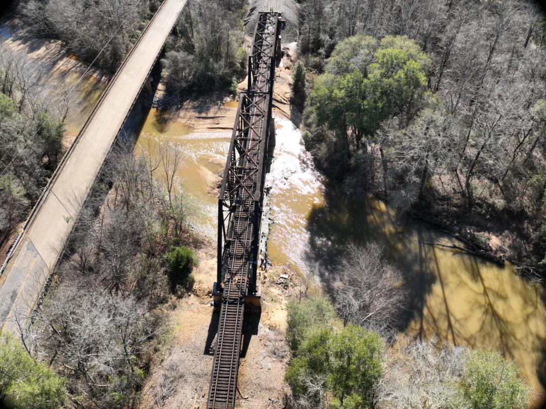
Historic structure, modern data. Today we were in Fremont documenting a 1906 railroad bridge, capturing top-of-rail shots, chords, and full span data to support engineering analysis for raising the bridge. Precise aerial and ground control ensure engineers have what they need to design with confidence?especially on legacy structures where accuracy matters most. Old bridges don?t forgive bad data. We don?t give them any.
Historic structure, modern data. Today we were in Fremont documenting a 1906 railroad bridge, capturing top-of-rail shots, chords, and full span data to support engineering analysis for raising the bridge. Precise aerial and ground control ensure engineers have what they need to design with confidence?especially on legacy structures where accuracy matters most. Old bridges don?t forgive bad data. We don?t give them any.
Historic structure, modern data. Today we were in Fremont documenting a 1906 railroad bridge, capturing top-of-rail shots, chords, and full span data to support engineering analysis for raising the bridge. Precise aerial and ground control ensure engineers have what they need to design with confidence?especially on legacy structures where accuracy matters most. Old bridges don?t forgive bad data. We don?t give them any.